| In This Newsletter: | Welcome to the 2nd installation of our revamped quarterly newsletter! In this digital publication you will find a diversity of articles on the wonders of the Amargosa that are sure to enlighten, including local geology, recipes, happenings, humor, and more! Curious to know more about your public lands? We've got the rolling series for you. Want to know more about Friends of the Amargosa Basin and the wonderful people that make advocating for this special landscape possible? Read on below. And, if nothing else, enjoy our precious desert (even in the sizzling summertime), and drink plenty of water! - Cameron Mayer, FAB Executive Director |
| P.S. With your help, we can continue to advocate for permanent protection for our local public lands and defend them from ongoing attacks, host wonderful free events (see our fall 2025 lineup below!), and keep you all informed on what's happening lately in this unique corner of the Mojave Desert southeast of Death Valley National Park. |
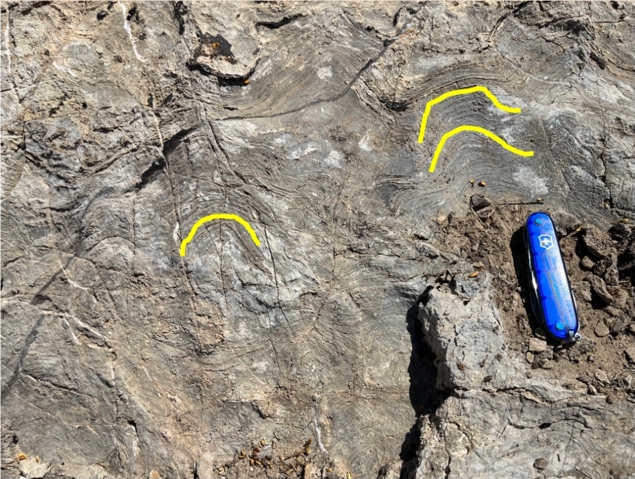
| | | A Record of Early Life on Earth, By Darrel Cowan | For about the first three billion years after Earth was formed, all life on the planet was microbial: mats and oozes of single-celled organisms, such as cyanobacteria. The proposed Amargosa Basin National Monument features outstanding examples of the record the microbes left in rocks: stromatolites. The microbes that built this example (see above) in the limestone of the Crystal Spring Formation in the Alexander Hills lived in the ocean sometime between 1.7 and 1 billion years ago. Microbes which created stromatolites were photosynthetic, and used sunlight to metabolize carbon dioxide [CO2] dissolved in seawater. Extracting dissolved CO2 caused calcium carbonate [CaCO3] to precipitate (solidify) out of the water. As this happens, it creates these vertical structures of stromatolites. In the idealized sketch (see below), a living microbial mat covers the surface of a stromatolite. A geologist investigating early life once told me that a good analogy of a microbial mat might be sticky dental plaque on one's teeth. Beneath the surface of a stromatolite mat are concentric (ring-like) layers of CaCO3: this structure shows that the microbes continually move upward to remain in the photic zone, i.e. the area exposed to sunlight. The living mat will be covered by grains of solidified CaCO3, but responds by extending hair-like structures, called cilia, upwards to form a new mat. The microbes then leave behind a limestone record of their life. No actual microbes survive in the rock, however. The microbes in early Earth had another very important incidental function: their photosynthetic metabolism (burning of energy gained from absorption of sunlight) produced oxygen. Oxygen was first dissolved in seawater, then released into the atmosphere. During the Great Oxygenation Event about 2.4 billion years ago, oxygen levels in the atmosphere and ocean eventually reached levels sufficient to sustain new, more complicated multicellular life forms!  A rendering of a stromatolite, showcasing the layers that build upon each other. |
|
|
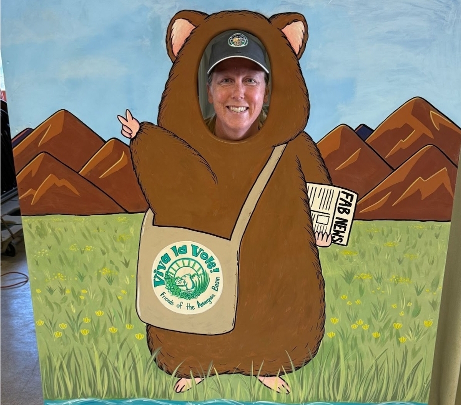
| | Getting to Know FAB: Elisabeth Kennedy, Volunteer | My first brush with the Mojave Desert came in 2011, when a geology field camp dragged me southward from Chico State to the stark beauty of the Salt Spring Hills, in the Amargosa Basin. Our crew holed up at the nearby Zzyzx research station, surrounded by sprawling vistas, bare-boned landscapes, and rocks so exposed it felt like Earth's geology was daring me not to notice it. This experience left a mark that never faded. Field camp opportunities brought me back three more times, and by the winter of 2013, after graduation, the desert's call was irresistible. My best friend and I, equipped only with a battered "Hikes of Death Valley" guidebook—this was 2013, remember, before social media gurus dropped pins everywhere—set out on a rambling, directionless ten-hour journey from Chico. Fortune soon intervened near Bishop, off Highway 395, at Browns Campground, where we encountered a wildly out-of-place steampunk fortress on wheels, inhabited by charismatic Blacksmith Gypsies. They welcomed us with tales, wisdom, and sharp recommendations: "The date shakes at China Ranch are mandatory," they insisted, "and the Tecopa Natural Hot Springs—non-negotiable." We pushed onward, trading hikes through Death Valley's unforgiving trails with episodes of spontaneous geological adventures and liberating my Honda Civic from a stubborn sandbank outside of Beatty, Nevada. Shoshone, to the south in California, appeared like a mirage, quaint and inviting. The town charmed me immediately, from the stickers at the Amargosa Conservancy office (now the Eco Center), to the quirky exhibits at the Shoshone Museum. But it was behind the China Ranch Date Farm, trekking towards a hidden waterfall, that I truly met the Amargosa River. This wasn't the roaring rivers of my Northern California childhood—it was an elusive trickle, flowing defiantly through the parched earth, eventually surrendering to Badwater Basin's expansive salt flat, California’s deepest low. Witnessing this stubborn desert river, indifferent to the ocean but letting gravity find it's way none-the less, was magical and profound. The date farm was surreal, its date shakes living up to reputation. Even the oddballs at the nearby hot springs seemed perfectly cast in this desert drama. And I'm nearly certain I spotted an Amargosa Vole—though last year's Vole Fest makes me doubt my rodent identification skills. It was likely just a humble cactus mouse. Leaving the Amargosa feels like abandoning a piece of myself every time, planting a fierce, wild craving that pulls me back across the vast distance now stretching from Arcata, CA. Each journey renews my inspiration, fusing seamlessly with my passion for art, science, and desert wanderings. Volunteering with Friends of the Amargosa Basin deepens my bond with this harsh yet tender landscape. Over more than a decade, my commitment to this dusty, captivating basin has grown fiercely protective and admittedly possessive. I selfishly wish the Amargosa Basin to remain untouched, ready to welcome my infrequent pilgrimages. I never expected my undergraduate studies would anchor me to a place hundreds of miles from my roots. Yet, through the vibrant community of Friends of the Amargosa Basin and my personal contributions, I've cultivated a stubborn sense of belonging—an unbreakable connection to a land where my heart steadfastly chooses to remain. See more art from Elisabeth below and on her Instagram page (@limestone_prints).
 An artistic depiction of a local scene by Elisabeth Kennedy. |
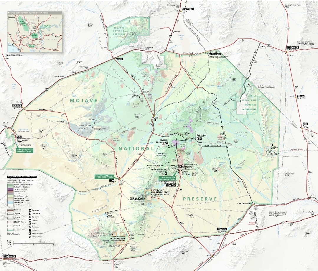
| | Diversity of our Federal Lands: Mojave National Preserve, By Janet Foley | The Mojave National Preserve (MNP) is an example of federal land dedicated to protecting natural and cultural values while also allowing some diverse uses. A great example is hunting: even though MNP is managed by the National Park Service, as a preserve there can be different allowances and some hunting is allowed at MNP. Also allowed are off-highway vehicle (OHV) use on designated routes, grazing and mining under valid rights existing at the time of designation, and the usual recreational activities such as hiking, birding, and more! The Mojave National Preserve includes the traditional lands of several tribal nations, including the Chemehuevi & Southern Paiute (Nuwuvi) and Mojave (Pipa Aha Macav). Indigenous peoples of this area have connections to this land from time immemorial ongoing to the present. This connection is represented through ties to various sites and traditional resources, as well as intimate knowledge of the landscape and its varied significance. In terms of recent Euro-American history, one of the first notable non-indigenous explorers of the Mojave region was Father Francis Garces who traversed what is now MNP in 1776, followed by Jedediah Smith in 1826 and John Fremont in 1844. In 1848, gold was discovered in northern California, and anyone could stake a claim on land where mineral deposits were discovered, according to the still-used General Mining Law of 1872. In the Mojave Desert, such minerals included copper, iron, gold, and silver, among others. As the years went by, ranchers increasingly used the land for their livestock as well. Other notable developments and occurrences began to leave their mark on the landscape, from early U.S. military activity and mail carriers journeying across the West, to researchers and enthusiasts exploring the unique local natural landscape, to the bizarre building of a mineral springs resort at Zzyzx, courtesy of desert denizen and radio evangelist Curtis “Doc” Springer, to the rise and fall of towns and the passenger railroad industry locally (which still maintains some freight operations through the area). The main visitor center of the Mojave National Preserve is at the Kelso Depot adjacent to the ghost town of Kelso, built originally to provision the Union Pacific Railroad. In 1994, MNP was officially established by Congress as part of the California Desert Protection Act (CDPA), integrating within its umbrella land that was previously part of the Bureau of Land Management's (BLM) East Mojave National Scenic Area (EMNSA). Final passage of the CDPA of 1994 is often largely credited to the unremitting advocacy of then freshly elected California desert champion Senator Diane Feinstein. MNP is the largest National Preserve (1.6 MILLION acres) in the contiguous United States, and incorporates Mojave, Great Basin, and Sonoran desert ecological environments. Some of its most prominent natural features are the Kelso Dunes, the New York Mountains, and Cinder Cone Lava Beds. It abuts State of California lands, such as the Providence Mountains State Recreation Area (SRA), which house Mitchell Caverns, itself a worthwhile visit. The natural history of the area is typical of the Mojave Desert, with a highlight being the extensive Joshua tree forests around Cima Dome, as well as critical habitat for the endangered desert tortoise, prairie falcon, and bighorn sheep. The preserve is replete with recent American history as well as enduring cultural and natural histories. The historic Mojave Road, a favorite for 4-wheel drive vehicle enthusiasts, is also itself a branch of the Old Spanish National Historic Trail (OSNHT). Another portion of the OSNHT is included in our Amargosa Basin National Monument proposal. The U.S. military has used the area for trainings and exercises, famously as part of the California Arizona Maneuver Area during WWII. Today, visitors often are just passing through, from Los Angeles to Las Vegas, or vice versa. For those inclined to stay longer, it is possible to camp in established sites or in the back country (as appropriate - check for relevant permitting). You can volunteer and help protect delicate desert ecosystems and biological and cultural values. And importantly, you can drive way out into nowhere and watch the stars, the moon, and a few satellites cross the skies. Enjoy these priceless public lands! |
|
|
| |
|
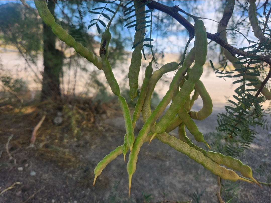
| | | Food For the Body and Soul, By Janet Foley & Cameron Mayer | Today, FAB Executive Director Cameron Mayer shares a delicious and refreshing Honey Mesquite Agua Fresca, with full credit due to the Imperial Valley Native Advocacy Group, who originally created the post on Instagram (@ivnativeadvocacy). This group does incredible work to educate non-native folks on the Imperial Valley's pre-colonial history. Check them out! A little about Honey Mesquite beans and their history: Honey Mesquite is indigenous to the deserts of North America, including the greater Death Valley region, Colorado River region, southern Nevada, and many other areas across the southwest. Since time immemorial, and continuing on into the present, this wonderfully nutritious plant has been/is an important traditional food source of native peoples. Mesquite sustains people and the land, weaving together the fabric of all desert life. Please respect this cultural heritage and associated connections when interacting with mesquite. Mesquite bean agua fresca ingredients: *Ripe mesquite bean pods (10-15 bean pods will do for a quart or so of agua fresca, with the latter figure recommended for a beverage with a fuller body of flavor). Pods are usually ready in late July to early August. Ripe pods are a solid yellow color and should come off of the tree with very little effort. If it takes a hard tug, it's not ready! Ripe pods may also be found on the ground after recently falling, however be very careful about using these as bugs or rodents may have gotten to them first. Check for holes or chew marks. And of course, be courteous and save plenty of beans for wildlife and others!Water the tree, or give back in some way, as reciprocity also matters. *Water (amount to suit jar or container of choice - a quart or so is generally recommended) *Sugar or sweetener of choice (optional but recommended) Step 1:In a pot, bring water to a boil as you wash your mesquite beans. Place the beans in the water and cook on low for 10-15 minutes until the pod turns a golden-brown shade. Step 2: Place mesquite beans in a blender with the boiling water. Do not toss out the water! It should be a yellowish color, which indicates that the syrup from the beans has steeped into it. Step 3: Blend the mesquite beans and water containing the steeped mesquite syrup (a blender with the capability to crush ice is recommended in order to avoid damage to the blades). The idea is to get at the cooked pulp that surrounds the seeds in the pods. We are not trying to crush the seeds! Step 4: Strain the blended pulp into a jug so that only the liquid (and not the pulp - unless you want that I suppose) is in the agua fresca. Add sugar and ice to taste. Step 5: Refrigerate and enjoy the drink to beat that summer heat! Honey Mesquite tastes very similar to the more mainstream Tamarind bean, sweet and tangy.
  Bottled Mesquite agua fresca (left). Mesquite agua fresca being enjoyed in a MNP cup (right). Now, with all this hydration, you’re going to have an appetite. Searching the internet, Janet found this absolute jewel, “ Rattlesnake Recipes by Desert Holly Ted and On de Rocks Mac”, https://www.holybooks.com/wp-content/uploads/Rattlesnake-Recipes.pdf, apparently written in 1950. She's chosen to highlight Jardiniere Amargosa, see below, and good luck sourcing the ingredients!!! (Anyone know what a jackass dripping is?)
 Photo from holybooks.com |
| A Little Desert Humor | |
Contributed by our friend KATHY NIXON: “We’re all here, because we’re not all there!" |
| Events & Notices | 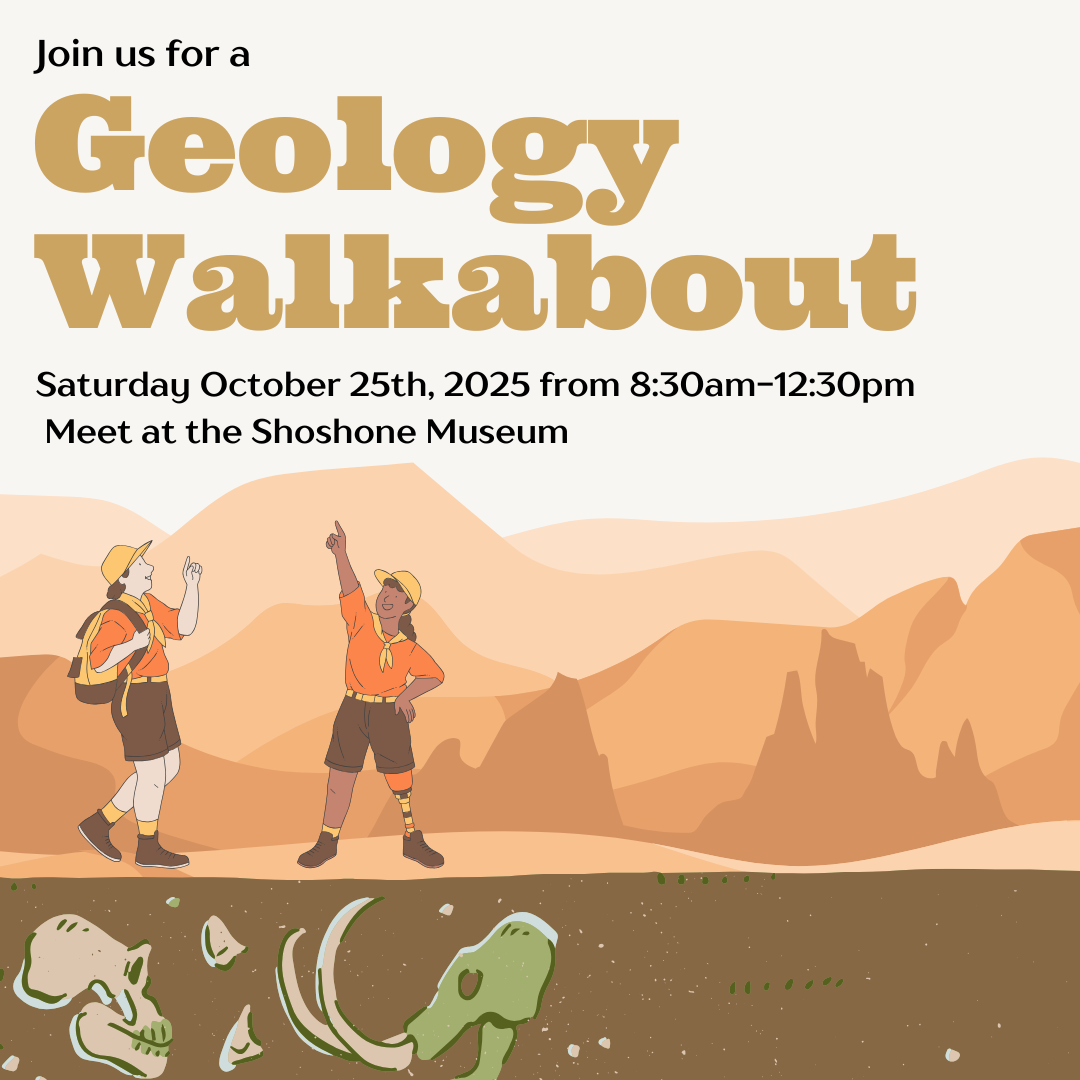 | Our lineup of events this fall will include: - A walkabout led by geologist and FAB board member Darrel Cowan on October 25th. Meet up in front of the Shoshone Museum. Start time is 8:30am. We expect to end by 12:30pm. Admission is FREE. No participant limit and no registration required. See the above flyer for more information. - A nature journaling event with artist Deborah Morgan on November 15th in Shoshone. Save the date and see the above flyer for preliminary details. Admission is FREE. There will be a limit of 20 pre-registered participants. Stay in contact with FAB and follow us on social media, send this newsletter to a friend (or friends), and check our website (https://friendsoftheamargosabasin.org/) for information, events, updates, and more! |
|  | |
|
| | | | Friends of the Amargosa Basin
PO Box 145 | Shoshone, California 92384
775.513.5065 | [email protected] |
| | |
|
| |
|
|